


Tropical depression east of Philippines forecast to become storm within 24 hours

VOV.VN - A tropical depression off the eastern coast of the Philippines has intensified and is expected to develop into a tropical storm within the next 24 hours before entering the northeastern North East Sea, with forecast winds of force 10-11 (89-117 km/h) and gusts up to force 13 (up to 149 km/h).
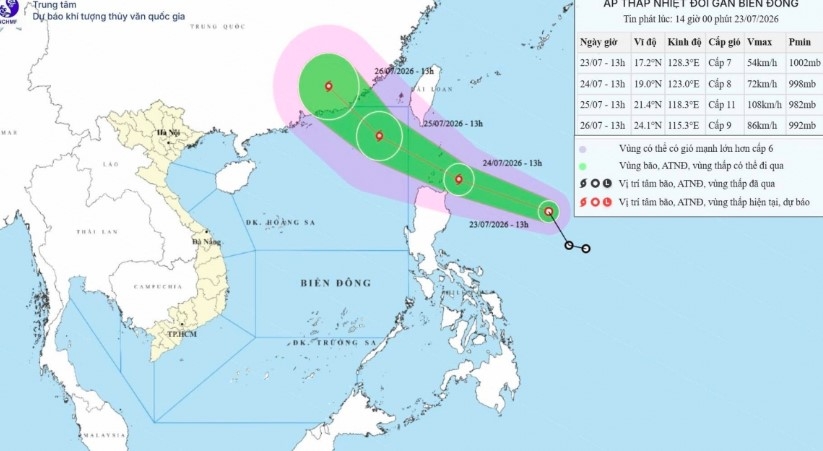
According to the National Centre for Hydro-Meteorological Forecasting, as of 1:00 PM on July 23, the system was centered in waters east of the Philippines with maximum sustained winds of force 7 (50-61 km/h) and gusts reaching force 9 (up to 88 km/h), moving northwest at 25 km/h.
Tracking west-northwest over the next 24 hours at the same speed, the system will gather strength into a storm. By 1:00 PM on July 24, its center is projected to lie roughly 100 km northeast of Luzon Island (Philippines), packing force 8 winds (62-74 km/h) and force 10 gusts (up to 102 km/h).
By 1:00 PM on July 25, the storm is forecast to reach peak intensity of force 10-11 (89-117 km/h) with gusts up to force 13 (up to 149 km/h) upon entering the northeastern section of the North East Sea. A Level 3 natural disaster risk warning has been issued for this maritime zone. Over the subsequent 48 to 72 hours, the storm is expected to move primarily northwest at 15-20 km/h while gradually weakening.
Due to the storm's influence, starting late afternoon on July 24, rough seas in the northeastern North East Sea will bring winds escalating to force 6-9, with areas near the storm center experiencing force 10-11 winds and force 13 gusts.
Waves will reach 2-4 meters, surging to 3-5 meters near the storm center. The meteorological agency warns that vessels operating in dangerous zones face high risks of thunderstorms, tornadoes, strong winds, and large waves, advising boat and vessel operators to closely monitor forecasts and take proactive precautions.

Low-pressure area over East Sea likely to strengthen into tropical depression
VOV.VN - A low-pressure area is active over waters in the eastern part of the northern and central East Sea and is likely to strengthen into a tropical depression within the next 24 hours, according to the National Center for Hydro-Meteorological Forecasting.